How well do you know the woods and waters of Cape Elizabeth? In celebration of CELT’s two most recent property acquisitions, we are releasing two self-guided walks to help you get to know Runaway Farm and Robinson Woods better.
As you are out and about this week, don’t forget to tag us @celtmaine on Instagram and Facebook!
Welcome to Robinson Woods! Today you have the opportunity to explore the newest addition to CELT’s Robinson Woods preserve. In 2019, the four Robinson brothers (Anthony, Michael, Peter, and Tyler) graciously sold CELT a 51.9-acre additional parcel of Robinson Woods, making it a 197.5-acre preserve. The Robinson family has been in Cape since 1720 and purchased what is now Robinsons Woods beginning in 1838!
Through three separate purchases by CELT beginning in 2003, Robinson Woods is now Cape Elizabeth’s largest permanently preserved parcel in town. It is comprised of beautiful wetlands, significant vernal pools, mature forests, a 7.5-acre pond, streams, and fields; all home to numerous birds, mammals, and amphibians.
Let’s Get Started!
1. Start at the parking lot on Shore Rd. Walk down Belfield Rd, the dirt road that starts between two stone pillars, for about 50 yards until you see a trail heading off to your left and into the field. Follow the trail along the edge of the field with the woods to your left.
2. The field you see in front of you has served many purposes over the years. In the 1920s the Smith and Beyer Family owned what was Robinson Woods II, which included the field. Until the Great Depression, the field was used by them as an airstrip for their plane with a hanger, and they also played polo on the field. The homestead was along the north edge of the field where Cranbrook exists today. The Smiths sold the land to the Robinsons around 1942. In the late 1940s and early 1950s, Wayneflete used the field to practice field sports. Over recent years the field was hayed. Today, CELT is in the process of restoring these fields to native grassland habitats, where CELT periodically mows the field.
3. As you continue along the trail, look through the trees on the left-hand side. Can you see the pond through the trees?
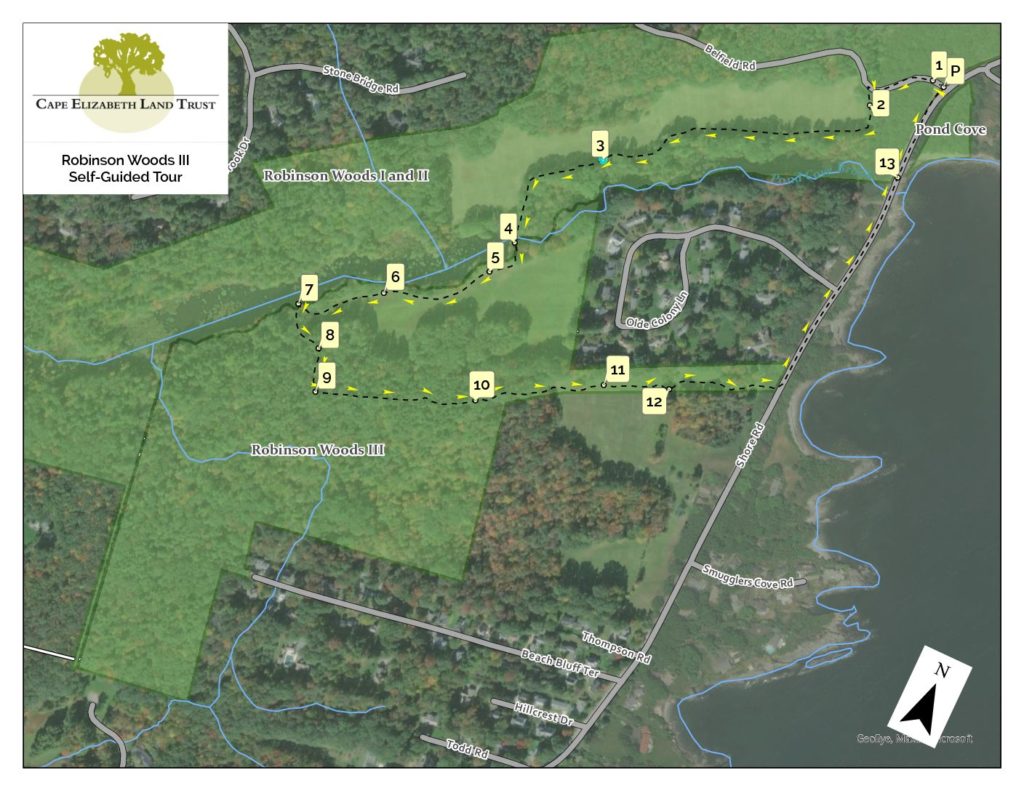
Do you notice many trees that have been chewed at the base the trunk?
Who do you think has been gnawing on these trees and why?
If you said beavers you are correct! Beavers gnaw at the base of trees to cut them down. They will eat the leaves, twigs, stems and even bark, then use the remaining branches and smaller trunks to build their dams and lodges.
Beavers are the largest rodents in North America and the second-largest worldwide. Being rodents, their teeth are constantly growing, so gnawing at trees helps keep them from getting too long as well as keeping them sharp!
Can you match this picture of a beaver gnawed tree to the actual tree in the woods?
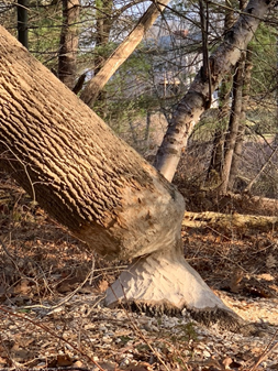
4. Continue along the trail as it takes you to the dam at the end of the pond. Here you will notice an interesting wire structure. This is a Beaver Deceiver!
The beavers have been living along the edge of Robinson Pond for the last 20-30 years. Over the years they have built several dams at different locations.
Why do they build dams?
Beaver build dams in areas of moving water to create still water or a pond where they then build their lodge. A lodge in the middle of the pond offers protection from predators such as coyotes, foxes, and bobcats.
Over the last few years, they have built a dam at the man-made dam where you stand. This caused the height of the pond to increase and weakens the structural integrity of the cement dam. One of our amazing stewardship volunteers came up with the ‘Beaver Deceiver’ you see at the location where the water enters the dam.
Can you tell how it works?
Was this always a pond? How might this body of water changed over the years?
Originally it was a convergence of streams that start near Beach Bluff Terrace, Fox Hill, and Pond Cove Brook by Purpooduck Golf Club. The stream was originally dammed to create a pond by the Smith and Beyer family in the 1920s. This family came from Boston to Cape as a summer residence and during that time it was typical to create a pond for leisure uses. Prior to the Smith and Beyer family, the land was used for agricultural purposes. We know this from the two old wells and a partial stone animal pen located on the Pond Trail across the field from the dam. Be sure to notice them the next time you walk along the Pond trail.
Continue along the trail as it borders the pond behind the Olde Colony neighborhood.
5. About halfway around the pond look out across the pond. Can you spot a beaver lodge on the opposite side? There is more than one lodge on the pond. On future walks, see if you can find others.
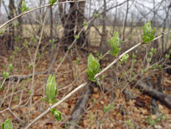
6. Walk a bit farther and you will find yourself walking through a nursery. What type of nursery is it and why is this nursery located at the edge of the field?
These are all young Eastern White Pines, our Maine state tree. These trees may be growing here due to the open canopy-there are no other taller, older trees blocking the sunlight.
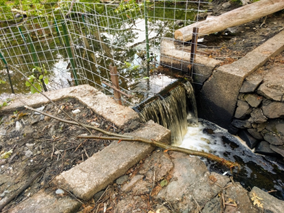
7. Follow the trail to the midpoint section of the pond.
Look out across the pond-what do you see?
You might notice some cattails from last season or maybe the old tree trunk lying in the water.
Did you know that cattails only grow in fresh water, not salt water?
How many seeds are in a cattail? A cattail head can contain up to 25,000 seeds!
The cattails will be in full bloom soon as well as lily pads and many other types of plant species.
Are there any waterfowl here today? How many different types of waterfowl can you see? As early spring moves into late spring and then summer this pond will come alive with plants and animals. Be sure to visit again to see the Eastern painted turtles basking on the logs, or frogs popping out at the edges of the pond, and the many songbirds who return to Maine.
Recognized as a particularly high-value habitat by the U.S. Fish and Wildlife Service, Robinson pond and the streams and emergent wetlands are a dynamic ecological system. Based on the Maine State Department of Inland Fisheries and Wildlife (IFW) data, this property includes an Inland Waterfowl and Wading Bird Habitat, a Significant Wildlife Habitat protected under the Natural Resources Protection Act. What does this mean? It means that this pond has excellent habitat for nesting and feeding shorebirds as well as a staging area; an area where migrating birds can rest, feed and prepare for migration.
Now take a sharp left and continue along trail.
8. You are now in a classic coastal oak/pine forest, composed of a mix of eastern white pine, eastern hemlock, and hardwoods including oaks. Notice how very straight and tall some of these eastern white pines trees grow. About 275 years ago trees just like these were used by the king of England’s naval fleet for ship masts.
Which one of these trees would you choose for your ship mast?
9. Walk a little further until you come to an intersection of trails.
Do you notice all the downed trees?
What do you think caused the trees to fall over and why did they all seem to fall in the same direction?
If you thought wind you are correct! These trees fell over during the strong storms we have had in recent years. There is so much rock and ledge here in Cape Elizabeth that often tree roots are very shallow meaning they grow outward more than deep into the ground. Many of the trees fell in a southeastern direction, blown by the wind coming off the ocean from the northeast. This is why we call some storms Nor’easters! Trees sink roots in relation to prevailing winds. Buttress roots form early – think of wind-blown trees on a coastal cliff that have had their canopies shaped by the wind. Nor’easters or other wind events blowing opposite the prevailing winds put stress on trees that they are not accustomed to.
10. At this point follow the trail as it turns left and keep your eyes out for woodpecker holes in trees.
Can you guess what type of woodpecker created these holes?
If you guessed Pileated woodpecker, you are correct!
You can always identify a Pileated woodpecker hole from other types of woodpecker holes due to its square or rectangular shape and large size.
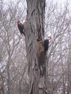
Have you ever seen a collection of fresh wood chips at the base of a tree? If so look up the tree trunk and you will likely find a freshly made woodpecker hole.
Keep your eyes out for any extra-large openings in a tree. These are often formed by the repeated work of a Pileated woodpecker and provide an excellent winter home for not only Pileated woodpeckers but owls and smaller mammals in the winter.
11. Follow the trail as it lets you out of the woods and into a field. About a third of the way into the field along the trail look for the first oak tree on the left.
Do you notice the disruption that has recently occurred under the tree?
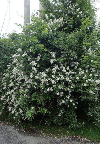
Over the years, honeysuckle and multiflora rose established themselves under the tree canopy.
How do you think these two plants effect the oak tree?
Both of these plants are invasive plants here in Maine. That means they are not native to our area but were brought in at one time, likely as a decorative plant for a garden or landscape. Now they are crowding out native species by taking resources, as well as choking many native plants.
Take a close look at the way the newer small branches are growing vertically on the main oak tree branches towards the sky. This branching structure is the tree’s response to stress, competing for the soil’s nutrients. Now that we have cleared the invasives from the tree’s understory, we are hoping to encourage healthy growth. We even found a young crabapple tree that may now have a chance to grow!
Also notice that there is a pile of rocks scattered around the tree. When mowing, farmers typically toss the field stones to a place where they’re out of the way.
12. Farther down the trail on the left, you will see another example of an invasive plant species killing a native maple tree. This tree was being “swallowed and choked” and slowly killed by bittersweet, another very aggressive invasive species.
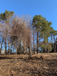
How does bittersweet kill a tree?
Bittersweet takes away precious resources and blocks access to sunlight, making it near impossible for the tree to produce food. Since acquiring this property in 2019, we have started to tackle the invasives to restore the field to its natural state. We have lots of work to do for the next couple of years to remove the invasives.
Take a look at both sides of the trail. We have cut the bittersweet vines that you see hanging from the trees and ground up the honeysuckle with a machine called a skidder.
If you have any of these invasive plants in your yard, we would encourage you to remove them too!
Continue along the trail until you see the Atlantic Ocean and you reach the Shore Road path. Take a left on the Shore Road path.
13. Did you know that CELT owns a small portion of Pond Cove beach! There is a trailhead that begins across Shore Road from the south end of the parking lot and leads to the beach.
We are also working on removing the honeysuckle on both sides of Shore Road here, to improve coastal habitat for plants and animals.
Be sure to take a walk over there to see if you can spy any waterfowl (ie. eider, cormorants, mallards). They love this protected cove, and it’s always fun to watch them bob in the water and catch the waves. How many different birds can you identify and count?
Thank you so much for joining us today at Robinson Woods! We hope you will explore our other properties and trails. We hope you had fun and learned something too!